Page 245
Town of Swanton, Franklin County, Vermont
David Skinas
USDA Natural Resources Conservation Service
July 2007
The town of Swanton's [REDACTED] Unmarked Burial Protocol (Zoning Bylaws Section 3.17 Native American Sites District) requires that an archaeological investigation be conducted on house development projects where ground disturbance will reach or exceed 18 inches below surface to ensure that any unmarked human graves are not inadvertently disturbed during house construction.
[REDACTED] of Swanton own a one-acre parcel on [REDACTED] (Figure 1) in the Town of Swanton and have filed an Application for a Building Permit to construct a single-family, one-story, three-bedroom residence, having dimensions of 72 feet in length and 47 feet in width. The property is located on the Southerly side of [REDACTED] in the Native American Sites District (Figure 2). Construction of a foundation and associated power, water, septic tanks and sewer lines would involve excavation to a depth of more than 18 inches.
[Image]
Figure 1. Project location shown on the East Alburg and Highgate Center USGS quad maps.
Page 246
[Image]
Figure 2. Location of house, power, water, septic tanks and sewer lines excavation.
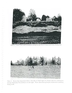
On May 30, 2007 I monitored the excavation of the house foundation. A straight-edged bucket was used on the excavator that removed soil below the plowzone in 4-6 inch increments. A buried barn foundation with concrete walls was exposed along the eastern end of the excavated foundation (Photo 1). The landowner remembered going to an auction at this barn in the 1970's. This farm and barn does not appear on the 1871 F. W. Beers Atlas of Franklin and Grand Isle Counties but does show up on the 1916 St. Albans, VT USGS quadrangle map. Sometime between the 1970's and present time this barn had been razed. On June 5, 2007 I returned to monitor excavation of the power, water and sewer lines once their locations had been determined. The septic would be placed in an area previously disturbed by the razed barn and installation of an 8 foot wide by 3-4 foot deep stone lined waterway (Figure 3 and Photo 2). The concrete floor of he barn's milk house was exposed midway along the sewer line that had to be avoided.
Page 247
[Image]
Photo 1. View of the barn foundation along the east third of excavated area, facing east.
[Image]
Photo 2. Shows the stone-lined ditch to the left of Chief April St. Francis [Merrill] and two contractors, Zoning Administrator Ron Kilburn is to the right. Photo taken during the preconstruction meeting, facing south.
Page 248
[Image]
Figure 3. Shows the location of the razed barn and stone lined ditch.
There was no evidence of any unmarked human burials, grave shafts, inhumations, cremations or red ochre features observed during the controlled monitoring of the house foundation or the power, water and sewer lines. No precontact Native American artifacts or cultural features related to other domestic or task-specific activities were identified. The monitoring effort only took about three hours of time during portions of two days to complete the investigation. It does not appear that construction of the [REDACTED] house and associated infrastructure will disturb or destroy any unmarked Abenaki burials.


